Great Allegheny Passage/C&O Canal Tow Path Trails Daily Comments
ABOUT
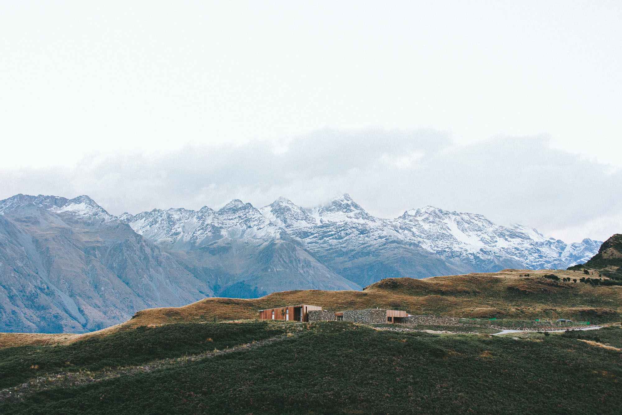
The Greater Allegheny Passage and the Chesapeake and Ohio (C&O) co-linked trails start/end in Pittsburgh Pennsylvania and end/start on the Potomac River in Washington D.C. The combined trail winds 350 miles through the eastern forests of Pennsylvania, West Virginia, Maryland, and then the District of Colombia.
I heard about the trails from friends who had ridden part of the Passage trail during a conference in Pittsburgh a couple of years ago. I've ridden a couple of trails in southern Maryland and in the District during visits to my family in Gaithersburg Md. I've wanted to ride solo through fall foliage, as a birthday present to myself, for my 68th birthday since I found out about the trail.
During my bicycle trip I will raise funds for BikeUtah's Youth Bicycle Education and Safety Training Program and Camp Kostopulos Dream Foundation-Opening a World of Opportunities for People of All Abilities. I'm riding solo through the autumn colors of eastern deciduous forests, and see my two grandchildren and their family for a few days. I am leaving SLC on the afternoon of October 10th and will hit the trail first thing the morning of October 11th in Pittsburgh. I plan to take it easy; ride a while, stop when I see something I want to look at, pop some Ibuprofen, maybe take a nap, ride some more and stay in one of the many towns along the trails.
The Greater Allegheny Passage is a converted rail-trail that meets the C&O Canal tow path trail (a National Park Trail) in Cumberland MD. It crosses the "Eastern Continental Divide" about 150 miles from Pittsburgh (the start of the Rail-trail). The C&O Canal broke ground July 4th 1828! It parallels (generally) the Potomac River and ends close to the Foggy Bottom area in DC.
I did not have access to the net for most of the trip! So feel free to comment on my posts, email questions, comments, etc. The posts start from the latest date I was on the trail (Oct 20) and go back in time from then.

September 27
Dropped my bicycle at REI in Salt Lake for them to box it for shipment. I have contacted REI in Pittsburgh, where the bike will be shipped to, so they can reassemble and have it ready for me to ride on the 11th of October. This is the first time in my biking life that I've not had a spare bicycle to ride in the interim. I feel lost!!
October 2
Making lists of what I have to do around the house and itemizing what I need to take, before I leave. Should I take camping gear? Rain gear? Camera? Should I wait to give the lawn the recommended winter blast of fertilizer until after I come back? When do I post on Facebook?
to leave. Flat tire on our car, the locking lug nut was broken. The car had be towed to the tire store. Time was ticking but I made it with time to spare, then the plane was 45 minutes late!
October 4
REI called. My bicycle is out of the book and ready to hit the trail!
October 9
Wow I leave tomorrow for my Fall Foliage Bike Ride!
I'll fly to Pittsburg tomorrow evening and then pick up my bike at REI on the Trail, clip on my panniers, buy some snacks, fill up water containers, and pedal towards D.C!
These are the two NGO's I'm raising funds for:
BikeUtah--raising money to teach grade school kids how to navigate our streets and ride safely on a bike to and from school.
Camp Kostopulous--raising funds to support the various programs the Camp offers to families and Campers of all abilities.
PLEASE support these two NGOs.
October 10
Flew to Pittsburgh via Minneapolis.
October 11 Pittsburgh to West Newton
The Fall Foliage Bike Ride is off to a great start.
Uber ride from the airport to REI:
Driver told me he had worked in the steel business for 27 years then his job and thousands of others were sent to China. I opined that the area seemed to be thriving. He said high-tech and other non-factory businesses were located in Pittsburgh.
“Do you think the steel industry will ever come back like it was?” I asked.
“No,” he said, “But if there’s ever a market for rust we’ll all be rich!”
“Some Presidential hopefuls say they will bring back jobs, revive the rust belt,” I said.
“Anyone who says they’re going to do that should have their urine tested for drugs, and anyone who believes them must be living in the land of OZ,” He responded.
REI—200 meters from the Three Rivers Heritage Trail in Pittsburg—had my bicycle ready to go. I loaded my overloaded panniers and camping gear and hit the trail. About four miles up river, the Three Rivers Heritage trail becomes the Greater Allegheny Passage (GAP) trail. The Monongahela river (say that three times rapidly) is lined with extinct steel mills. Derelict equipment serves as interpretive sites; monuments to another time. Most steel production in Pittsburgh went to China decades ago. Rust is everyplace, bridges, abandoned steel mills, railroad yards, discarded refractory buckets, ex-steelworkers. But Downtown Pittsburgh is vibrant, clean, and smog free. The city seems to be thriving doing fine without big steel.
Bicycles are everywhere downtown and on the Southside. An effort has been made to segregate bicycle lanes or at the least, on shared roadways, to paint a generous bike lane often delineated with plastic poles. Trailside businesses have sprung out of the sandy banks along the trail close to the river.
The Greater Allegheny Trail (GAP) is paved to McKessport PA. After that, GAP is a mixed surface trail, albeit in great condition. The trail skirts the outside of the old steel mill areas along the river. It appears that one of the major products being produced are huge pipes whose ultimate use is a mystery. These also are rusty.
Day one ends, after several side trips or stops to do bird watching, grab a snack, try to answer, when asked by locals, why I’m riding a bicycle from Pittsburgh to DC. The most common comment is: “You could fly there or take Amtrak and be there in just a couple of hours.”
Checked into the Bright Morning B& B In West Newton P.A. No Wi-Fi, will post when I get a connection.
The Bright Morning B&B is three houses next to each other. The houses were very well renovated and the inn keepers and staff very friendly if not effusive. The B&B is next to the trail to the point that if you don’t make a slight curve below the houses you will end up in the bike storage garage. It’s a bit pricey but after walking into town I can see why.
West Newton—across the river from the B&B-- is, to be gentle, a rundown and crumbling town. It was, according to a few people with whom I visited, settled well over a century ago to support the railroad shipping iron ore, coal, coke, and men and supplies to Pittsburgh and the coal mines in the area.
It is clear that in its time West Newton was a vibrant community. The downtown shows, through its architecture, that it once thrived. There were several banks, shops, restaurants, now all boarded and closed. Houses along the residential streets were well-made brick structures, many showing the wear that their owners must feel.
Except for the innkeepers and their staff at the B&B, West Newton reflects the wear and tear of a declining economy in an eroding town. This is Trump country! I kept my politics and opinions to myself but if he happens I hope his delusional promises works for them.
The GAP trail is incredible. It steadily climbs alongside the Youghiogheny River at between 1 and 1.8 percent grade. The eastern deciduous forests some of which are showing the colors of autumn line the trail. Autumn is late this year I’m told. There are some bicyclist going and coming on the trail, and a few hikers.
Breakfast at the Bright Morning B&B was adequate. I met a couple from Anchorage Alaska also staying at the B&B—Nora and Harold. She was working as a tax accountant and he, I believe, was a retired surveyor who had worked in his home state of Alaska; a very pleasant couple. The innkeepers agreed to mail my camping gear home. Risky behavior, sending my gear home, but. . . I hope it works out. We said our fare-the-wells and I mounted up.
Next stop: Melody Motor Lodge in Connellsville, PA.
October 12 West Newton to Connellsville
The GAP is lined with hardwoods typical of the western side of the Appalachian range. There are lots of leaves but many are still green. But for someone raised in the Four-Corners and who lives in Utah, green is everywhere. The canopy closes over the constant grade of the trail. The book promised between 1 and 1.8% grade. It appears flat but it’s uphill. The eyes say to the brain: this is flat. The legs say to the body: no, it’s uphill, look at the river next to you, it’s flowing downhill, you’re going against the current. But depending on your fitness, age, ability, you pick a pace and stay with it.
There are numerous coal mines (closed), close to Dickerson Run, shielded from view by the deciduous forest of southern Pennsylvania. Next to the trail are the remnants of coal tipple’s that presumably loaded coal on trains headed for the steel mills in Pittsburgh. I stopped at a bench--great view of the river close to a coal tipple--to fix a riding shoe clip. A huge man came out to somewhere and stood immediately in front of me. He was at least a head taller than me (would make him close to six foot eight) had a boxers battered nose; sunglasses and was wearing a foul smelling running suit.
Him: “What are you doing here?”
Me: “Tightening the remaining screw on my clip.”
Him: “Are you a Bolshevik? Are you here to kill Bolshevik union miners?”
(Note: I think a Bolshevik was a member of a labor movement started by Lenin)
Me: “No, I’m just fixing my shoe. I lost a screw on my clip.”
Him: (his voice ramping up along with hand gestures) “Mellon and that Carnegie, who came here as a Bolshevik (?), turned on the labor movement and hired people to kill union guys.
Me: “Wow, sorry to hear that. I’ve got to go.”
Him: (voice high pitched) Want to see one of the coal mines around here? You can’t throw a rock without hitting one.”
(Note: just before I left Salt Lake I was in a conversation about the movie Deliverance. Scenes were running through my mind. But two bicyclists were coming up the trail towards us.)
Me: “Hey, there’s the rest of my group. Have to go.” (I jumped on my bike and swerved around him)
Him: (yelling) “You F. . .ing Bolshevik killers. Someone’s going to shoot all of you F. . .ing biking killers!”
He was still yelling and cursing when I made the next bend.
Connellsville PA only function seems to be an impediment to high-speed traffic, an inhabited speed bump, to traffic on Highway 119. You enter and exit the GAP at a trailside bike shop: Bikes Unlimited.
In the trail book it suggests that the Melody Motor Lodge is in close proximity to GAP. Definition is everything. It is close—it’s about a mile uphill on Highway 119. I don’t know where the highway comes from or goes to but it is done at high speed except at stoplights. The motel—vintage nineteen fifties—is clean but threadbare. It is operated by an older woman (70ish) who says she’s Russian. She had an accent, but was friendly and ready with advice about places to eat. And she said Trump was an idiot.
Turns out Nora and Harold are also staying there!
October 13 Connellsville to Confluence
40% chance of rain is a downpour! My waterproof windbreaker was soaked through between the motel and the cafe. Breakfast in Connellsville was a test of gastric fortitude but cheap. Bikes Unlimited is the place to stop for everything bike, in Connellsville. They adjusted my rear disk brake and found a couple of extra screws for my clips.
There’s a movie where the zombies or monsters are coated in white clay. After a few miles I was one with them. My bicycle, panniers, shoes, and rain pants were coated in white clay.
Fighting the bicycle for stability for 35ish miles in slick mud is exhausting.
Nora and Harold discussed visiting Falling Water (the Frank Lloyd Wright designed house a few miles from Ohio Pyle) but after slogging through falling water most of the day and trouble getting tickets we skip it. Everyone travels at his or her own speed so I rode off alone after lunch while they looked around town.
A few miles south of Confluence the rain stopped. I was wet, cold, and cranky.
But the woman who operates the Rivers Edge B&B knows how to deal with these issues. “Take a hot shower and I’ll leave a glass of Chardonnay on the kitchen table for you.” The B&B was a bargain; my room comfortable with a river view. My trail friends Nora and Harold found another place across the bridge in the main part of town. We met for dinner at yet another place that offered, “home cooking.”
Tomorrow Meyersdale.
October 14 Confluence to Meyersdale
Todays ride was dry; no crazed Bolsheviks. Ecologically the forests have been changing as I gain altitude. Sprinkled in the hardwood canopy are, I think, some eastern hemlock. (I didn’t stop to verify) The fall colors aren’t as vibrant as I thought they would be, especially at lower elevations closer to Pittsburgh. The trees are showing more color with altitude but are still holding on to green. I can’t get a consensus from locals about the lack of fall colors. Some say that as I approach Meyersdale, that the colors will get better.
The landscape about is getting more open, more farms, vistas, and fewer trees to muffle town, train, and traffic noise. Ridge tops sprout wind generators. I’ve read that the Casselman river has good whitewater rafting and kayaking. There’s good fly-fishing someone tells me.
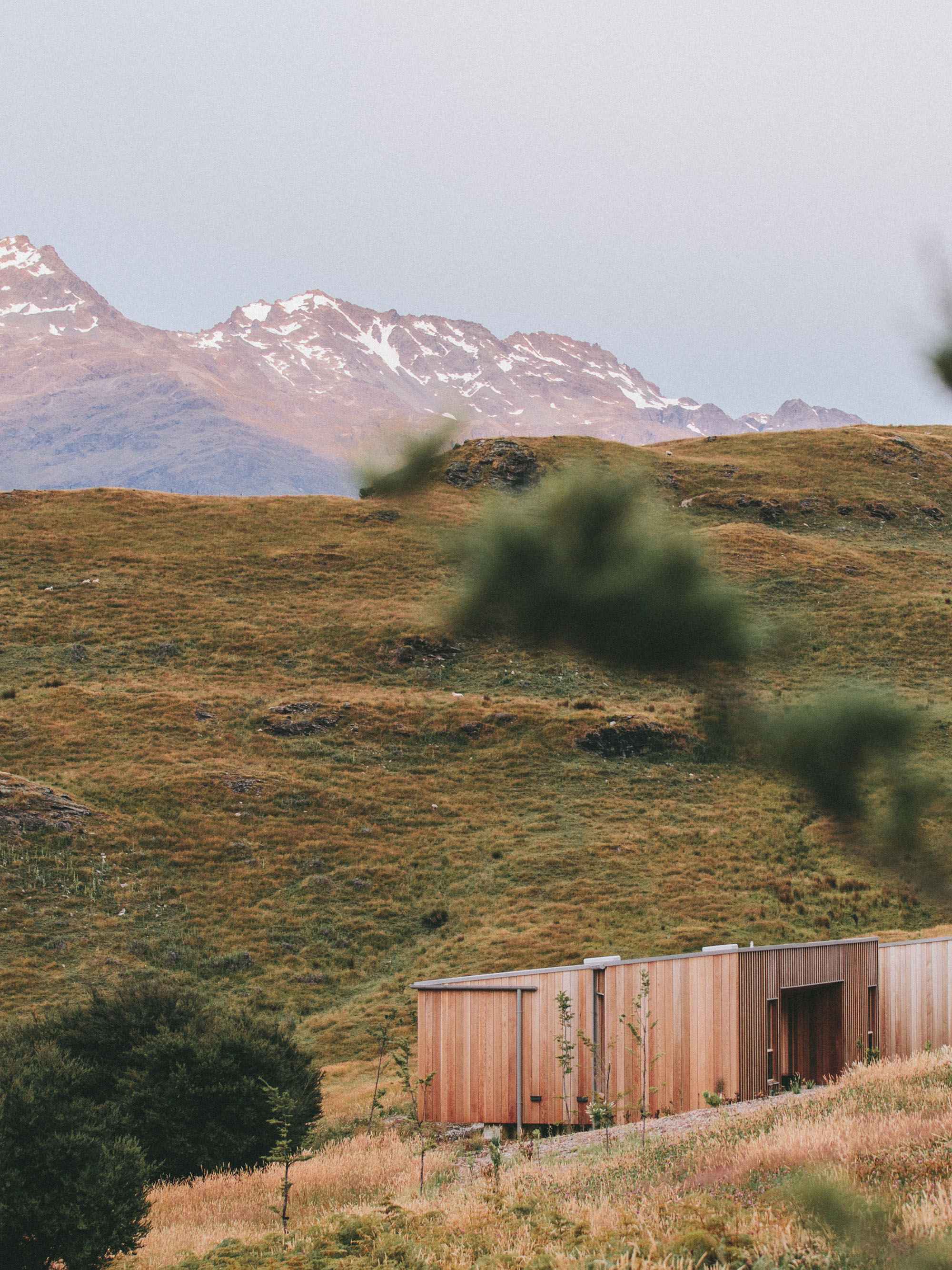
Just before you get into Meyersdale GAP crosses over the Salisbury Viaduct, 1,908 ft. long. The GAP trail has been built on an abandoned iron railroad trestle high above Highway 219. The view of the valley is superb. Wind generators and old open-pit mine spoils piles don’t detract from the view. The spoils piles have been replanted.
The ecology is changing but the towns are struggling, having rough times. From the vantage point of the Meyersdale Railroad Station Visitors Center (historic), on the GAP Trail, the town seems different from others but as one drops into it there are boarded shops, buildings in disrepair.
The Yoder’s Guest House is one of several two-story brick homes that have resisted hard times. The innkeeper has done a remarkable job renovating the building. I have a one bedroom with kitchen suite!! Reasonably priced as well.
My Alaska friends stay in a huge building a block away. Harold tells me there have been several businesses in the building including a mortuary. The restaurant on the second floor is the only real eatery in town that isn’t fast food. If you stay at Yoder’s Guesthouse go to the local market and buy some supplies and cook your own.
Tomorrow it’s a steep climb back to the Railroad Museum to get on the GAP, then a short ride (20 miles) to Frostburg where I’m staying at a place named “Charlie’s Motel.”
October 15 Meyersdale to Frostburg
Today’s the day I cross the Eastern Continental Divide (altitude 2392 ft.), ride through the Big Savage Tunnel (3294 feet long but lit), cross the Mason/Dixon Line, drop into a slightly different mixture of deciduous trees, and maybe find different political views. My bike friends Nora and Harold, who rode with me today, decide to ride on to Cumberland. They are starting their return journey back to Anchorage Alaska. They pedaled off to Cumberland and I looked up a very steep hill to get into Frostburg from the GAP. Charlie’s Motel is up even more steep hills. Charlie’s Motel is cheap but clean, Charlie is a gregarious man who says if you book directly with him you can call and he’ll shuttle you from the trail to his motel.
Had breakfast at the only place open in Frostburg on a Sunday: Shift Café. Try the pancakes!
I was told by a grandmother eating at the cafe with her grandson, that she didn’t care what “he said” because she was voting for him because they (Trump and she) were in the same party. I hadn’t said a word to her about politics. How did she know?
October 16 Frostburg to Cumberland
Rode the deserted streets of Frostburg (it's Sunday), downhill, to the GAP. The trail to Cumberland was great. The Western Maryland Scenic Railroad shares the old rail grade. I foolishly thought (because I was coasting at speeds higher than I had pedaled on the rest of the GAP) and if the trail remained at this wonderful grade, I could be in D.C. in a couple of days!
Staying at the Fairfield Inn in Cumberland a hundred yards from mile zero of the C&O Canal Tow Path.
Celebrated finishing the first 150 miles with Nora and Harold at the Crabby Pig close to mile zero. Imagine a vegetarian finding something to eat in this place. But, I made do! A glass of chardonnay helped. I said my goodbyes to Nora and Harold. It was great to make such friends.
October 17 Cumberland to Little Orleans
This morning is the first that I haven’t had to layer clothing because of the chill (35-40 deg. early morning) on the GAP. It is a balmy 55 deg. in Cumberland with an expected high close to 80! The C&O is different than the GAP and I quickly found out that the average grade wasn’t much different than that on the GAP. The system of locks and the magnitude of the planning, construction and operation is staggering.
At Lock 75 I stopped for tea and a snack. A man, his wife, and an early teen son stopped. The man said: ”Do you know anything about bikes?”
Me: “I know a little bit,”
Him: “This seat seems to slip down and I feel like I’m falling off the back.”
(Note: the saddle had been put on the post backwards and then turned so the front end was pointing forward but at an extreme angle, the front significantly higher than the back.)
Me: “We can fix it I said. A few miles more and you might need to ride to D.C. in an ambulance.”
(Note: I fixed it and they took off for Hancock 60 miles away. Time:9:45 a.m.)
The C&O Tow Path varies from a single track to a double track for most of the 184.5 miles. Wildlife is plentiful and varied. All along the path I saw Cardinals, Eastern Jays, various woodpeckers, crows, ravens, and Bald eagle. Deer (white-tailed) jump across the track or sometimes jump onto the towpath and bounce ahead, their white flag tail waving.
I see very few people on the trail. The campgrounds along the way are empty but great places to stop for a break.
The Paw Paw Tunnel (3,118 ft. unlit) is and engineering marvel. The towpath through to tunnel is about five feet wide with a wooden guardrail to keep bikes and pedestrians from falling into the water. The tunnel walls are brick. The trail is hard surfaced but potholed by dripping water and you should not attempt to ride your bicycle trough the tunnel. It is pitch black and the walking surface is very rough and slick.
I was gearing up (mounting a headlamp to my riding helmet) to enter when the people with the broken bike rode up. I don’t know where I passed them.
Him: ”Do you have an extra flashlight?”
Me: “Sorry I only have this headlamp and the light on my handlebar.”
Him: “It doesn’t look that dark. You can see light at the other end. We’re going to have lunch and then go through.”
Walking through the tunnel wasn’t difficult just awkward because of the uneven and slippery surface and it was dark. I turned off my headlamp briefly and wondered how the family was going to make it.
At Fifteen mile Creek Campground they caught up with me again.
Him: “Do you have any spare water?”
Me: “Sorry I have maybe a couple of swallows left. Little Orleans is just around the corner.”
Him: “Can we buy bottled water there?”
Me: “I don’t know what’s there.”
I left them debating, rode the rest of the way to Little Orleans, climbed yet another steep hill into what could be called a ghost town. The family followed me into town a few minutes later. I was sitting on a bench waiting for the shuttle to take me to the Little Orleans Lodge. They were frantic, knocking on doors, their voices getting higher. No one home. It was five p.m.
Me: “There’s a hose at that house across the street.”
Him: “We don’t drink untreated water or water from a hose. We have to be in Hancock by six. We have reservations.”
Me: “Maybe the place where I’m staying in Little Orleans has extra space. Hancock is twenty-five miles further and it will be dark by six thirty.”
(Note: Never give unsolicited advice especially to people who give the impression they know it all.)
Him: “It doesn’t get dark that early.”
Me: “Okay then.”
October 18 Little Orleans to Hancock
The Little Orleans Lodge is a bit interesting! The innkeeper is in his early eighties and is a walking example of how someone with ADHD ages. I’m ADHD! I think I see part of my future. I'm hungry for more than peanuts and granola bars. The Innkeeper took my on a scenic drive overlooking the Potomac River. The view of that part of West Virginia is unobstructed from the river to the crest of the Capapon He is a kind but very opinionated man. He doesn’t like either of the Presidential Candidates but he dislikes Trump the most.
Him: “Trump is an arrogant, d..khead, bully, a..hole.”
What could I say?
Him: “Did you see the bear in the yard?”
Me: “Uh, no.”
Him: “What do you know about bears, the Civil War, dogs, . . . .?”
(Note: If he is an example of aging ADHD, my ADHD future will be fascinating if not even more conflicting.)
The house (Inn) is disorganized, somewhat messy, but clean.
And he bakes a great loaf of wheat hearth bread. At breakfast he cut off into a quarter and gave it to me for a snack later in the day.
Never did see the bear. Off to Hancock wondering if I will find the dehydrated family I last saw in Little Orleans.
October 19 Hancock to Willamsport
Hancock is probably the most unremarkable town I’ve visited. —still no Wi-Fi! I wonder if, after all of the trials and tribulations the thirsty family went through yesterday, if they thought Hancock was Nirvarna.
Fort Fredrick is about halfway to Williamsport. It was a colonial fort built for the French and Indian Wars. A sign noted that I had to have a ticket to visit the fort. But, I was the only one there. No tour guides, gift shop sales people, history buffs, only a few crows in the maple trees.
I did see a bear. Looked like a two year-old. It came out of the river side of the trail, stopped to sniff at me then beat a hasty exit up the hill. Made it to the Candlelight Inn B&B mid afternoon. The woman who runs the place gave me a map of historic sites for my walk-about. George Washington, according to an interpretive sign, came to town to decide if it should be the nations capital. The final decision was D.C.
October 20 Williamsport to D.C.
I had the best breakfast I’ve had on the entire trip at the Candlelight B&B. For some unfathomable reason, during my breakfast tea, I decided not to stop in Brunswick and, instead, ride to D.C in one day. In hindsight, my brain must have been as numb as my butt when I made this decision. Maybe I should have looked at the map. Instead, I was influenced by the fact that rain was forecast for the 21st. The memory of slogging through wet clay between Connellsville and Confluence, on the GAP side of the Eastern Continental Divide, weighed in on what could have been a very poor decision.
American history, seeps from the earth along the GAP and C&O Canal. Williamsport was the site of a ferry in 1744, purported to ferry trappers and explorers across the Potomac. But Williamsport didn't become a permanent settlement for a couple of decades. In 1744 California was being seriously explored by the Spaniards and English and French explorers had established trading posts but not permanent settlements. Santa Fe in northern New Mexico had been settled in 1607, the second permanent community in what is now the continental U.S. The first was St Augustine, Florida, settled in the mid-16th century. To Europeans it was empty. However, the vast area between the Pacific Ocean east to the European communities close to the Atlantic, had been settled for centuries by various sophisticated Indian Nations. But that area had few Europeans except explorers when the ferry at Williamsport was built.
There are Civil War skirmish and battle sites all the way from Hancock to D.C. Many were skirmishes—Hancock, Williamsport, Monacacy, South Mountain however, battles at Sharpsburg, Antietam, Harpers Ferry were as horrific in scale as Gettysburg, and the many battles in Virginia and other states. I’ve been in the Army and when my family visited these places several years ago I could not imagine the horror. It was hard to grasp the scale and savagery, even through my eyes. I still can’t.
If I believed in ghosts this area would be the place of haunts; American Indians, European explorers and trappers, blue and gray uniformed soldiers rubbing shoulders, all shaking their heads in disbelief that humans could be so divided or intent on colonization that they sacrificed many, many, thousands of lives to seize land or as in the Civil War, to prove a point. The irony is that across the country, including Salt Lake, there are those who would decimate landscapes, cultures for power or profit. Some across the nation are still fighting the battle. These are the rebel flag flappers, the “birthers”, the closet segregationists, some politicians and community leaders.
South of Whites Ferry--just east of Leesburg, Virginia (also a community with a violent Civil War history)--I was drinking the last of my tea and snacking wondering what had possessed me to attempt to finish my GAP/C&O Canal trail journey in one day. I still had at least thirty-five or more miles to complete by dark, just a few hours away.
Finally Georgetown and the return ride back to the Great Falls Tavern Visitor Center using the same headlamp I used in the Paw Paw Tunnel. I had met a man, who owns a bike shop in eastern MD, on the trail south of the Visitors center. I was starving, tired, and my legs were shaking. He suggested we have dinner at the Old Anglers Inn so he could pick my mind about riding the trails. He drove me to my daughter’s home in Gaithersburg. I can’t believe I rode over 100 miles today. Why?
Quisque iaculis facilisis lacinia. Mauris euismod pellentesque tellus sit amet mollis.